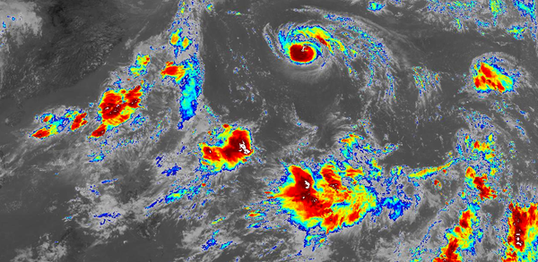
GEO-KOMPSAT-2A (GK-2A) is a geostationary weather satellite operated by the National Meteorological Satellite Center of the Korea Meteorological Administration. It is positioned over the equator at 128.2°E longitude which is visible from Australia, New Zealand, Southeast Asia, Japan, Korea, China, Indi...
Read more
The Pmod Standard developed by Digilent is a peripheral protocol, interconnect and form-factor guideline supported by various FPGA and microcontroller development boards. Digilent manufacture a wide varie...
Read more
Since its commissioning on July 25th 2019, GEO-KOMPSAT-2A (GK-2A) has been downlinking Full Disk images every 10 minutes over LRIT and HRIT. Unfortunately the LRIT downlink only transmits a single Infrared channel called IR105 (10.4μm) due to throughput constraints. This means false colour imagery cannot be created using data from the LRIT downlink alone.
However, interesting imagery can still be created from this single cha...
Read more
Between Monday 2nd and Friday 5th of July 2019 the KMA NMSC conducted testing of their new geostationary weather satellite GEO-KOMPSAT-2A (GK-2A). This post is a summary of the testing carried out during this period, as well as s...
Read more
This map is a collection of various types of satellite ground stations located across Australia. Types of marked sites include large telecommunication hubs, deep space tracking stations run by NASA/CSIRO and the ESA, control centers for commercial satellite operators, broadcast uplink/distribution nodes, and rural Nation...
Read more
Like NOAA's series of GOES meteorological satellites, COMS-1 (128.2°E) operated by the Korea Meteorological Administration (KMA) has both LRIT and HRIT downlinks for disseminating real-time meteorological data. Unlike GOES, these downlinks are encrypted using single-layer DES and decryption keys are controlled by KMA th...
Read more